 I’ve been sleeping better than I have all year since arriving in Colorado, but the night before our big descent I woke up about 300 times. The temperature was in the low 40s when Paul and I left my parents’ house, and up on the canyon’s rim the wind was a little brisk. We signed in with a young ranger who managed to convey the serious nature of our endeavor without making us feel incompetent. Then we filled out our permit and set off along the trail at about 10:15.
For the next hour and a half we made steady progress along the Gunnison Route. http://www.americansouthwest.net/colorado/black_canyon_gunnison/hiking.html It was just as challenging as expected without being scary. The biggest concern would be during the ascent, when it’d be easy to get lost on the unmarked route. During the passage down, whenever we reached a spot that seemed potentially confusing we turned around and gazed up at it, studying it for a few moments trying to memorize the route. A couple of times I took a picture with my digital camera - the modern day version of leaving a trail of breadcrumbs, I suppose.
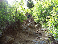
 Within about 20 minutes we were descending very steep stretches strewn with jagged chunks of granite, quipping occasionally, “So, why do they call it the ‘Rocky Mountains?’” When we got to the chain about which we’d been forewarned, I tried at first to climb down without using it. The wall was so steep and rocky I changed my mind before taking my second foothold.
 After the chain ran out, the rest of the route alternated between steep scree fields, steep boulder and dirt paths, and one long, steep patch of snow that some rangers later told us had been the result of a late season avalanche.
In case it isn’t totally obvious, the entire journey was never not steep. A 1,700 foot drop, according to the website, that covers about the same horizontal distance. Steep.

At the bottom we walked along the beach and found a nice spot for a picnic. We noshed on peanut butter and banana sandwiches, apples, gorp and lots of water. We listened to the roar of the Gunnison River and Paul even dipped his feet into the 38-degree water. I washed my bandana and splashed my face and that was enough for me.
The upward climb was tricky but we managed to avoid the pitfalls. The temperature had risen to about 75 degrees so we actually broke a sweat climbing up. Turned out we were the only scramblers to make the descent that day, which made us feel awfully proud of ourselves. At the top again we felt so energized that we decided to add an extra two miles and strolled along the Oak Flat Loop. There were some nice views of the canyon we’d just penetrated, plus lots of cool shade and Colorado wildflowers.
It was no 14er, but it was a pretty good substitute for us. Next year we’ll return in July or August and see if some of that snow has melted.
1 comment:
Thank you for that bit of vicarious exhilaration. Beautiful! and I so admire your adventurous soul.
Post a Comment